
.jpg)
These boundaries were not arbitrary; they maximized geographical advantages for guerrilla warfare, exploited proximity to the Indian border for supplies and training, and targeted key Pakistani economic and military assets.
Chittagong District: The Coastal and Urban CoreChittagong District formed the western and coastal foundation of Sector 1. Bordered by the Karnaphuli River to the north, the Bay of Bengal to the south, the Hill Tracts to the east, and Feni district to the northwest, this area included the bustling city of Chittagong and its world-class port.Chittagong Port was the lifeline of East Pakistan's economy, processing 80-90% of the region's imports and exports. More critically for the war, it served as the primary entry point for Pakistani military reinforcements, weapons, ammunition, and fuel shipped from West Pakistan. Disruptions here could cripple the occupation forces' logistics across the eastern front.Early resistance erupted in Chittagong city and cantonment following Operation Searchlight on March 25, 1971. Bengali soldiers defected en masse, providing the initial manpower for Mukti Bahini units. The district's relatively flat terrain allowed initial conventional clashes before shifting to guerrilla tactics.Chittagong Hill Tracts: The Vast Guerrilla StrongholdTo the east and southeast stretched the Chittagong Hill Tracts (CHT), a sprawling highland region covering over 13,000 square kilometers. Its boundaries followed natural features: India's Tripura and Mizoram states to the north and east, Myanmar to the south, and the plains of Chittagong District to the west.Characterized by hills rising to 1,000 meters, dense tropical rainforests, deep valleys, and rivers like the Chengi and Sangu, the CHT was a natural fortress. Pakistani mechanized forces—tanks, artillery, and trucks—struggled to operate effectively in this terrain. Narrow, winding paths became death traps for ambushes, and thick canopy limited aerial surveillance and strikes.The indigenous tribal communities—numbering hundreds of thousands, including Chakma, Marma, Tripura, and others—offered invaluable support. They provided intelligence, acted as guides through hidden trails, supplied food and shelter, and many joined the fight directly. This unity between Bengalis and hill tribes created a resilient rear base for sustained operations.Key locations within the CHT, such as Rangamati town, Kaptai Dam, and Ramgarh, became focal points for raids, sabotage, and defense. The sector headquarters at Harina was established deep in these hills for security.The Belonia Bulge: The Northern Border FlashpointThe northern boundary of Sector 1 extended into parts of Feni and Noakhali districts, specifically the Belonia Bulge—a narrow, finger-like protrusion of East Pakistani territory into India's Tripura state near Belonia town. Bounded by the Muhuri River, this small enclave (approximately 20-30 square kilometers) held outsized strategic importance.Its position directly threatened Pakistani communication and supply lines along the Dhaka-Chittagong highway. More importantly, the bulge's proximity to the Indian border allowed Mukti Bahini forces to infiltrate easily from Tripura-based camps, establish early liberated zones, and launch raids deep into enemy territory.The Belonia Bulge witnessed some of the war's earliest and fiercest battles, starting in June 1971. Mukti Bahini units, often in coordination with Sector 2, defended against multiple Pakistani counterattacks, holding ground and expanding control along the Muhuri River.Why These Boundaries Were Decisively AdvantageousThe overall boundaries of Sector 1 created a porous frontier with India, facilitating arms smuggling, fighter training in Tripura camps, and the exodus of millions of refugees—a humanitarian crisis that galvanized international support.The diverse terrain forced Pakistani troops (primarily elements of the 24th Infantry Division and paramilitaries) to disperse thinly across vast areas, making them vulnerable to hit-and-run tactics. Mukti Bahini controlled rural and hilly regions, isolating urban garrisons and denying free movement on key roads.Sub-sectors like Ramgarh, Belonia, and others operated semi-autonomously from Harina HQ, allowing flexible responses to enemy movements.By December 1971, these boundaries framed the final offensives. Guerrilla pressure paved the way for advances that liberated Chittagong city and port on Victory Day.The delineation of Sector 1 turned natural geography into a powerful ally for liberation, proving that strategic boundaries could level the playing field against a larger conventional army.Joy Bangla! The boundaries of Sector 1 etched the eastern frontier of Bangladesh's freedom struggle.
Battles in the Belonia Bulge – northern boundary hotspot
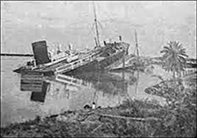
Operation Jackpot targeting ships in Chittagong Port

Kaptai Lake and hills in Rangamati – heart of the Chittagong Hill Tracts
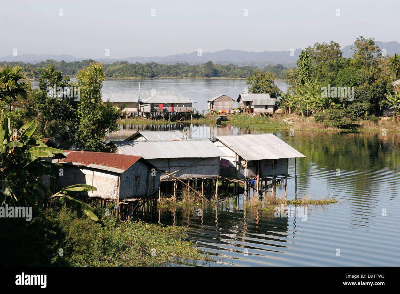
Serene Kaptai Lake in the rugged Chittagong Hill Tracts
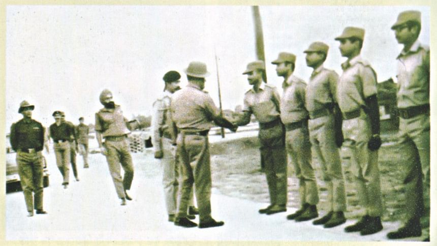
Mukti Bahini defending the Belonia Bulge

Mukti Bahini freedom fighters operating in Sector 1 terrain

Mukti Bahini guerrillas training near the borders
Sector 1 Visual Gallery • 1971 Bangladesh Liberation War
.jpg&description=These boundaries were not arbitrary; they maximized geographical advantages for guerrilla warfare, exploited proximity to the Indian border ...)